
ArcGIS Toolbox – Using a Layer File to Update Layer Properties
(If you’re using Firefox, then right click and Save Link As) Download the Update Layer Properties Toolbox View the Source Code (any donations go towards hosting costs) The Update Layer Properties tool updates a layer’s…
ArcGIS Toolbox – Create Unique ID with ArcPy
(If you’re using Firefox, then right click and Save Link As) Download the Create Unique IDs Toolbox – works with ArcGIS 10.1+ View the Source Code (any donations go towards hosting costs) ** Run this tool…
ArcGIS Toolbox – Calculate Point Statistics within Polygon with ArcPy
Updated – 2/27/2015 Fixed compatibility with Python 3 for ArcGIS Pro (If you’re using Firefox, then right click and Save Link As) Download the Calculate Point Statistics Toolbox – works with ArcGIS 10.1+ View the Source…
ArcGIS Toolbox – Create Points on Polylines with ArcPy
Updated – 9/17/2017 Fixed error dealing with setting spatial reference Updated – 5/04/2016 All polyline fields are now included in the output Point feature class Updated – 4/14/2016 Added additional INTERVAL point creation types Fixed…
ArcGIS Toolbox – Shorten Polylines by Percentage or Distance with ArcPy
Updated – 4/10/2015 Can now shorten the polylines from both sides, this keeps the middle part of the polyline Previous Updates Fixed compatibility with Python 3 for ArcGIS Pro Output polylines now retain original vertices,…
Featured

ArcGIS Toolbox – Create Points at Corners of Polygon with ArcPy
(If you’re using Firefox, then right click and Save Link As) Download the Create Grid Corner Points Toolbox – works with ArcGIS 10.1+ View the Source Code (any donations go towards hosting costs) The Create Grid Corner Points tool creates a point at each corner on…
ArcPy
GIS Resources Python Add-in for ArcMap
Select your version of ArcMap: Download the GIS Resources Python Add-in for ArcMap 10.1 Download the GIS Resources Python Add-in for ArcMap…

Bing and Google Maps Python Add-in for ArcMap
Updated – 2/4/2015 Fixed backwards compatibility with 10.1 Added exception…

Google Street View Python Add-in for ArcMap
Updated – 2/4/2015 Fixed backwards compatibility with 10.1 Added exception…

ArcGIS Toolbox – Generate Random Points with ArcPy
Updated – 2/27/2015 Fixed compatibility with Python 3 for ArcGIS…
ArcPy Resources
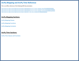
ArcPy.Mapping and ArcPy.Time Reference
This is an offline reference for the ArcPy.Mapping and ArcPy.Time modules in PDF format. It includes classes, functions and constraints. I tried…

GIS
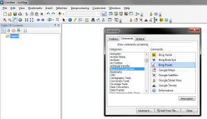
ArcGIS Desktop – Tutorial On Customizing ArcMap Toolbars and Keyboard Shortcuts
ArcMap allows for a large amount of customization. It’s just a matter of taking the time to set it up the way…

Using a mosaic dataset to create a tile cache from an existing web service
Download the Image Boundary Polygon This step-by-step guide will show…

Scripts
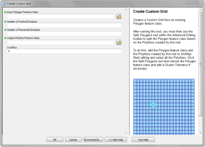
ArcGIS Toolbox – Create a Custom Polygon Grid with ArcPy
Updated – 7/15/2015 Fixed line movement from setting Overflow value, now based on slope Updated – 2/27/2015 Fixed compatibility with Python 3 for…

Creating a Quarter Quarter Section Grid with Python
Updated – 7/15/2015 Fixed line movement from setting Overflow value, now…